

In many fast-growing cities, electric bikes and scooters are now a core part of daily mobility, but they also create serious enforcement and safety challenges. Shenzhen, a megacity with more than four million electric bikes, has faced persistent issues such as red-light running, riding against traffic, speeding and illegal modification. Traditional enforcement based on officers standing at junctions and chasing individual offenders simply cannot keep pace with this volume. To address the problem, Shenzhen has combined RFID technology with drone patrols to build a data-driven, highly automated model for managing electric bike traffic at scale.
Background: From Manual Enforcement to Systemic Control
Before the new system, Shenzhen’s authorities relied heavily on “manpower enforcement”. Officers were deployed at key junctions and corridors, often reacting to incidents after they occurred. This approach made it difficult to capture short, high-risk behaviours such as a quick red-light jump, or to build an evidence chain that linked a specific person and vehicle to a specific violation. With millions of bikes spread across a complex urban road network, it was almost impossible to gain a real-time picture of where the risks were concentrated.
The city needed a way to identify every compliant vehicle reliably, detect unsafe behaviour as it happened, and link that behaviour to a trusted data record. It also needed to move away from intuition-based deployment of officers towards a more analytical approach grounded in real operational data. That combination of requirements led to a new architecture built around RFID electronic plates and coordinated drone patrols.
Solution Overview: Integrating RFID Electronic Plates and Drones
At the heart of the system is RFID, used to provide each compliant electric bike with a unique “electronic identity card”. A passive RFID chip is embedded into the number plate, requiring no battery and activating only when it receives a radio signal from a reader. When a handheld reader or fixed roadside base station transmits that signal, the tag responds with the vehicle’s registered information. Since 2021, Shenzhen has progressively rolled out these electronic plates citywide, reaching coverage of more than ninety per cent of electric bikes.
Above the streets, drones act as the “eyes in the sky”. Equipped with high-definition cameras and on-board image recognition, they can patrol complex urban environments on a routine basis. Purpose-designed traffic management drones offer around forty-five minutes of endurance, typically flying between fifty and one hundred and twenty metres in altitude and covering a radius of up to three kilometres. Video and event data are streamed in real time back to the traffic command centre over 5G or other high-bandwidth links.
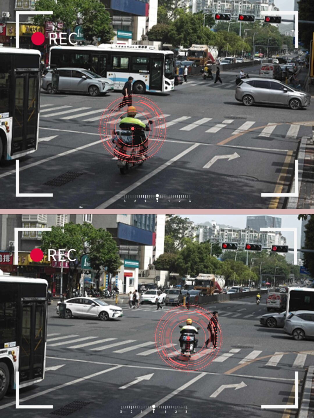
The real power comes from combining the two. When a drone detects a suspected violation or unsafe situation, the command platform immediately cross-references data from nearby RFID base stations to identify the vehicles involved. Ground officers receive precise prompts on their mobile terminals, showing which vehicles to stop and where, creating a tightly integrated “sky and ground” enforcement loop.
How the System Works in Practice
On a pilot corridor in Shenzhen’s Bao’an district, this architecture has already demonstrated its value. During the morning peak, a drone patrolling an intersection might observe several electric bikes running a red light. The onboard system flags the behaviour and sends the relevant frames to the command centre. Within around three seconds, the backend associates each vehicle in the footage with RFID reads from the nearest roadside base stations, completing an evidence chain that links time, location, images and a specific electronic plate.
At the same moment, officers stationed at the next junction along the route receive an alert on their terminals. As the flagged vehicles approach, they already know which bikes to intercept and can handle the case calmly and safely instead of relying on visual recognition under time pressure. This combination of aerial imaging and RFID identity means short-lived violations can still be captured and processed rigorously.
The system extends beyond pure violation capture. In traffic incidents involving electric bikes, drones can often arrive at the scene faster than ground units, capturing a full-scene view to support subsequent investigation and liability decisions. RFID reads from the area provide confirmed identities for the vehicles involved. In sensitive locations such as schools, transport hubs and retail districts, drones provide continuous oversight of electric bike flows, allowing control centres to intervene early when overcrowding or unsafe behaviour emerges.
Stolen vehicle tracking is another important application. When an owner reports a theft, the electric bike’s RFID identity is added to a watch list. Any subsequent detection of that tag by a roadside base station or within a monitored area triggers an alert. Over the first year of operation, the system has reportedly helped identify and intercept more than one thousand two hundred stolen electric bikes, preventing significant financial loss for residents.
Impact: Data-Driven Governance and Measurable Results
Inside the Shenzhen traffic command centre, large screens now present a live, data-driven picture of electric bike activity across the city. Heatmaps show where bikes are concentrated, where violations are most frequent and how flows evolve over the course of the day. Instead of assigning officers based purely on experience, planners can see clearly which junctions and corridors require attention and when.
The impact on road safety has been notable. Since the system was fully deployed, serious violations such as red-light running and riding against traffic by electric bike users have fallen by around thirty-seven per cent. Reported traffic accidents involving electric bikes have decreased by roughly twenty-eight per cent. Response efficiency for incidents has improved by close to a factor of five, as the command centre can direct the nearest officers with precise information instead of relying on incomplete reports from the field.
Equally important is the shift in enforcement philosophy. The city has moved from “people standing in the road” to “data guiding decisions”. Officers can focus their time on the locations and behaviours where they make the most difference, while the RFID and drone infrastructure provides continuous monitoring in the background.
Future Roadmap: Towards a Connected Urban Mobility Network
The integration of RFID and drones is only one element of Shenzhen’s broader smart traffic strategy. Looking ahead, there is clear potential to connect this system with the city’s wider “urban brain” platforms. Signalised junctions could adjust green time dynamically based on real-time electric bike volumes, smoothing flows and reducing conflict with other modes. Artificial intelligence could move from retrospective analysis to proactive risk warning, identifying unhelmeted riders or phone use and sending immediate spoken or digital reminders.
Further, by combining RFID with temperature and other sensors, authorities could monitor charging behaviour and battery safety risks, identifying overheating or unsafe installations before they lead to incidents. At the regional level, data-sharing between neighbouring cities could support cross-boundary enforcement and planning, creating a more coherent approach to micro-mobility across an entire urban cluster.
For city authorities and system integrators in other regions, the Shenzhen case shows how RFID and drone technologies can be orchestrated into a practical, large-scale solution for managing electric bikes. The key ingredients are a robust identification system, sufficient coverage of readers and aerial observation, a high-performance data platform, and a governance model that uses insights from the system to guide real-world operations.
